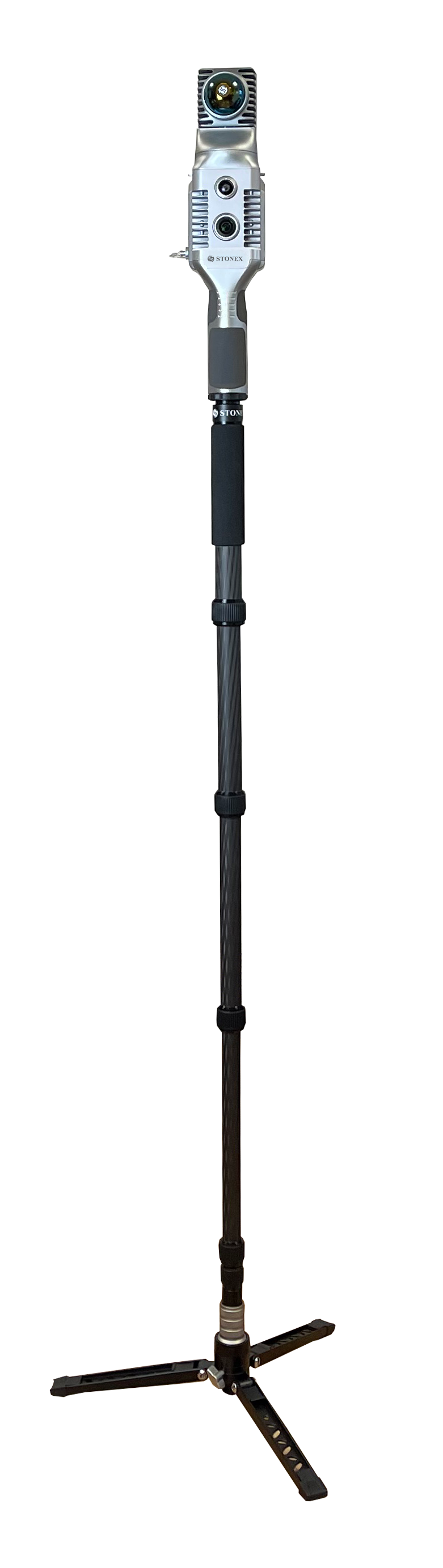
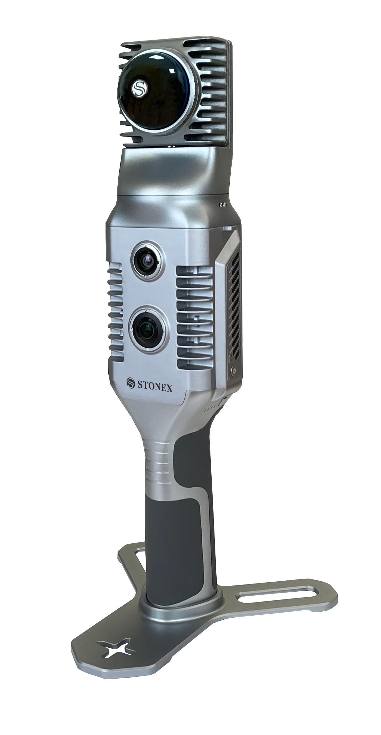
Stonex X70Go SLAM LiDAR
The X70Go is a LiDAR-based SLAM system that uses a laser sensor to generate a 3D map of its environment. LiDAR (Light Detection and Ranging) measures the distance to an object (for example, a wall or pole) by a pulse from its laser scanner. It uses an advanced onboard processor to keep track of its location whilst the scanner moves through the area.
An operator using the X70Go can quickly build up a 3D model of a complex area in minutes from turning on. The field acquisition takes as long as it would take to walk in and around the project area. It makes an ideal tool for mapping a cave for Archaeology or a tunnel in underground mining. Other applications might be to quickly survey an accident scene or for an As Built survey at a construction site.
The X70Go can be setup on a tripod, during a mobile scan, to take a more detailed and textured result of key areas around the site. It can also process the captured raw using its own processor to produce a 3D point cloud (LAS file) immediately after you have finished scanning. This saves a lot of time processing the data back in the office and the need for taking laptops and other equipment to the job site. No more multiple scan stations, just move around the scene to collect the entire 3D point cloud, without time-consuming cloud to cloud alignment. See in real time your scanning progress using the included Android App.
Reference points (targets) can be placed prior to scanning the project area. Control points can also be collected whilst capturing data for the point cloud. The processing software can then use these points to geo-reference the point cloud in real world coordinates.
The X70Go has two integrated cameras, that cover the wide field of view of the laser scanner, to obtain coloured point cloud imagery and panoramic images. YouTube video is here
the X70Go Standard package is $20,000 exGST and includes
Hard shell protective case
Handle with the internal Lithium ion battery
Base plate to support the X70Go and for GCP survey.
AC Wall charger and power cable
GO App for Android tablet
GOpost software and a USB dongle
Calibration test report.
Bundled Software.
The GO App is the mobile application for X120GO to use when scanning points. It also manages projects, real time point cloud display, image preview and firmware upgrades. This App runs on the Android operating system and suited to the UniStrong / Stonex range of tablets that we sell.
GOpost is used to post-process the data collected by the X120GO to produce high-precision point clouds, local panoramas, optimize point cloud results, and the ability to browse point cloud. This software runs on Windows 10 or higher.
Stonex and 3rd party software
Stonex Cube-3d is Photogrammetric software for post processing LiDAR and photo images to create maps and volumes. It can transform image data into highly accurate digital maps and 3D models with extreme precision. It can import Stonex’s Cube-a surveys and the scanned imagery from GOpost as well as being fully compatible with any third-party 3D models.
PointCab Thanks to the collaboration between Stonex and PointCab, you can manage your point clouds with it. PointCab Origins is your Swiss army knife when it comes to the evaluation of point cloud data – working with all laser scanners and compatible with all CAD and BIM systems.
| Laser scan Performance | System Specification | ||
| Maximum range | 70 metres | Memory | 512Gb SSD |
| Minimum range | 0.1 metres | Operating Mode | SLAM mode and Static mode (X-Whizz) |
| Relative Accuracy | up to 6mm in controlled enviro. | Processing mode | Real time processing and Post processing. |
| Vertical Resolution | 16 channels | ||
| No. of points per second | 200,000 points | Power Specification | |
| Field of View | 360° horizontal and -7° to 52° vertical | Power Consumption | 20 Watts |
| Laser Class | Class 1. | Operating Time | 1.5 hours |
| Echo Strength | 8 bits | Capacity | 3,000 milli Amp hours |
| Camera Performance | Physical Specs. | ||
| Resolution | 12 Megapixels | Weight | 1.45kg |
| Diagonal FOV | 100° | Size | 365mm x 174mm x 170mm |
| Focal length | 3.24mm | Operating Temp. | -20°C to 50°C |
| Sensor size | 1 inch | Operating Humidity | < 95% Relative Humidity |
| Pixel size | 1.55 | Waterproof / Dustproof | IP54 rating |
X70Go Accessories Click for information | AUD exGST |
| Monopod stand for X70Go | $100.00 |
| RTK module for the the X70Go | $4,000.00 |
| Backpack frame for the RTK module | $2,200.00 |
| Battery handle for the X70Go – spare | $800.00 |
| GOpost software dongle key – replacement | $380.00 |
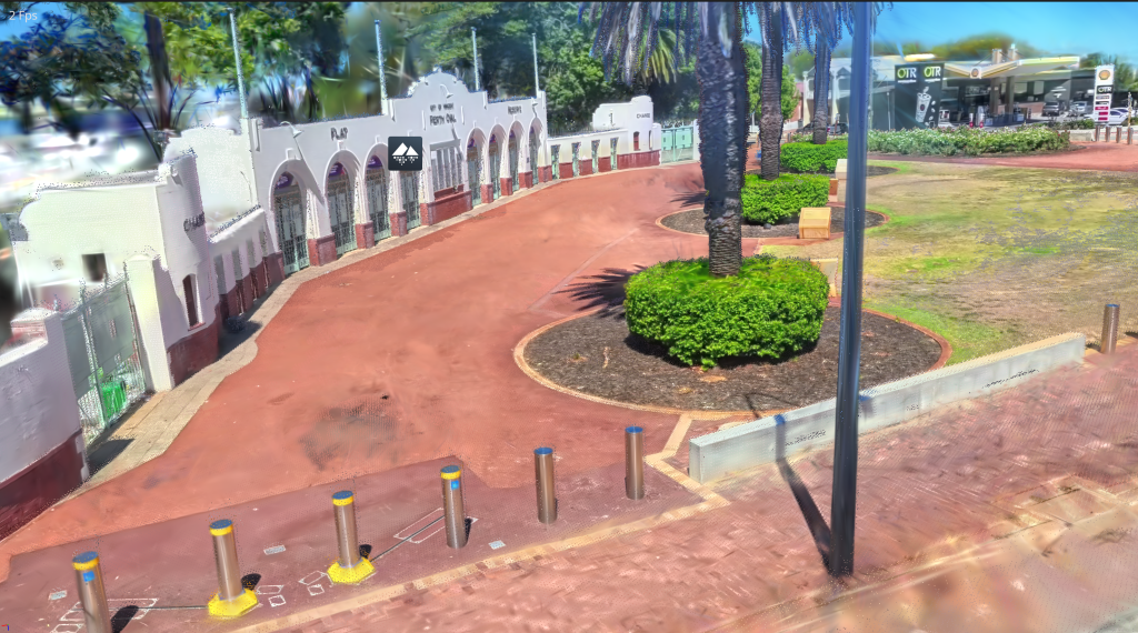
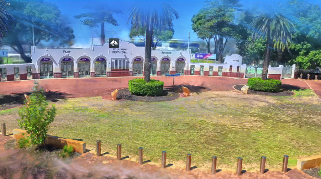
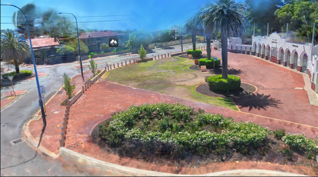
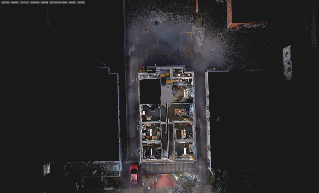
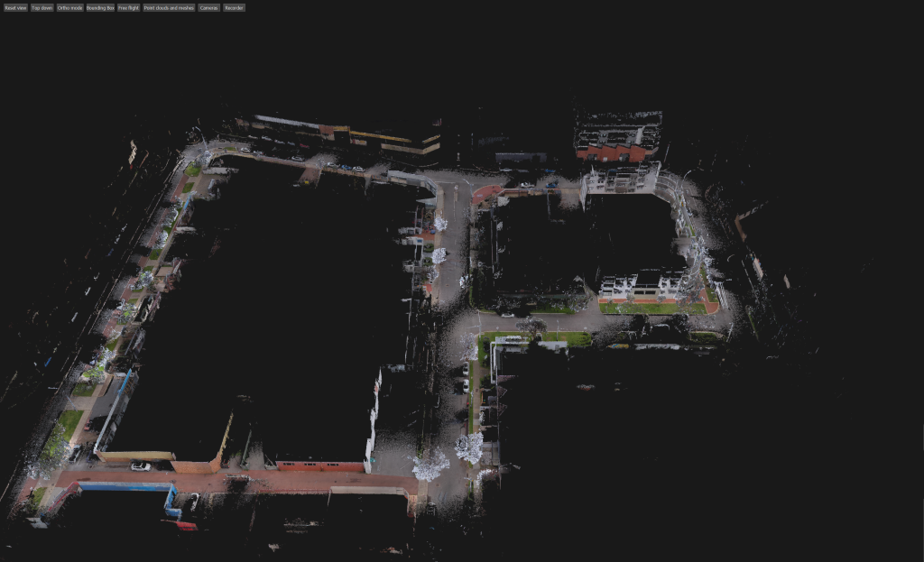
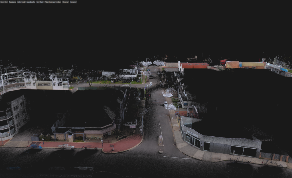
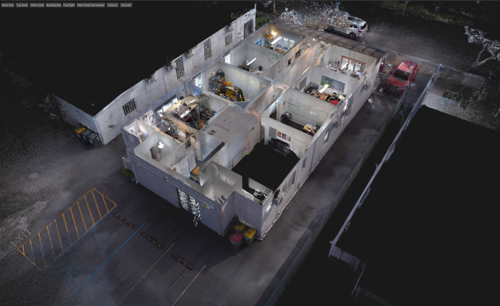
Examples of Point Clouds Captured with the Stonex X70 Go
The Stonex X70GO offers a fast, flexible alternative to traditional terrestrial laser scanners by combining SLAM mobility with high‑quality LiDAR capture. Unlike static scanners that require multiple tripod setups, targets, and long acquisition times, the X70GO allows operators to walk through an environment and capture data continuously, dramatically reducing field time. Its lightweight handheld design makes it ideal for indoor mapping, tight spaces, multi‑level structures, and rapid site documentation where moving a tripod is slow or impractical.
While terrestrial scanners excel in ultra‑high‑precision static measurements, the X70GO provides efficient, real‑world productivity, delivering dense point clouds suitable for BIM, facility management, construction verification, and asset documentation. For teams needing speed, mobility, and ease of use, the X70GO offers a powerful and cost‑effective solution that complements or replaces traditional static scanning workflows.
Gaussian Splat Creation with the Stonex X70GO
The Stonex X70GO can now generate Gaussian Splat models directly by combining its SLAM‑based point‑cloud data with panoramic imagery captured using an Insta360 camera (purchased separately). After scanning an interior or structured environment with the X70GO, the dataset is processed entirely in Stonex GOpost for optimisation, colourisation, alignment, and direct Gaussian Splat creation—no third‑party software required.
GOpost outputs the final Gaussian Splat model in .ply format, delivering a streamlined, end‑to‑end workflow that transforms fast, mobile SLAM capture into immersive, photorealistic 3D scenes ideal for building documentation, facility mapping, and digital‑twin applications.