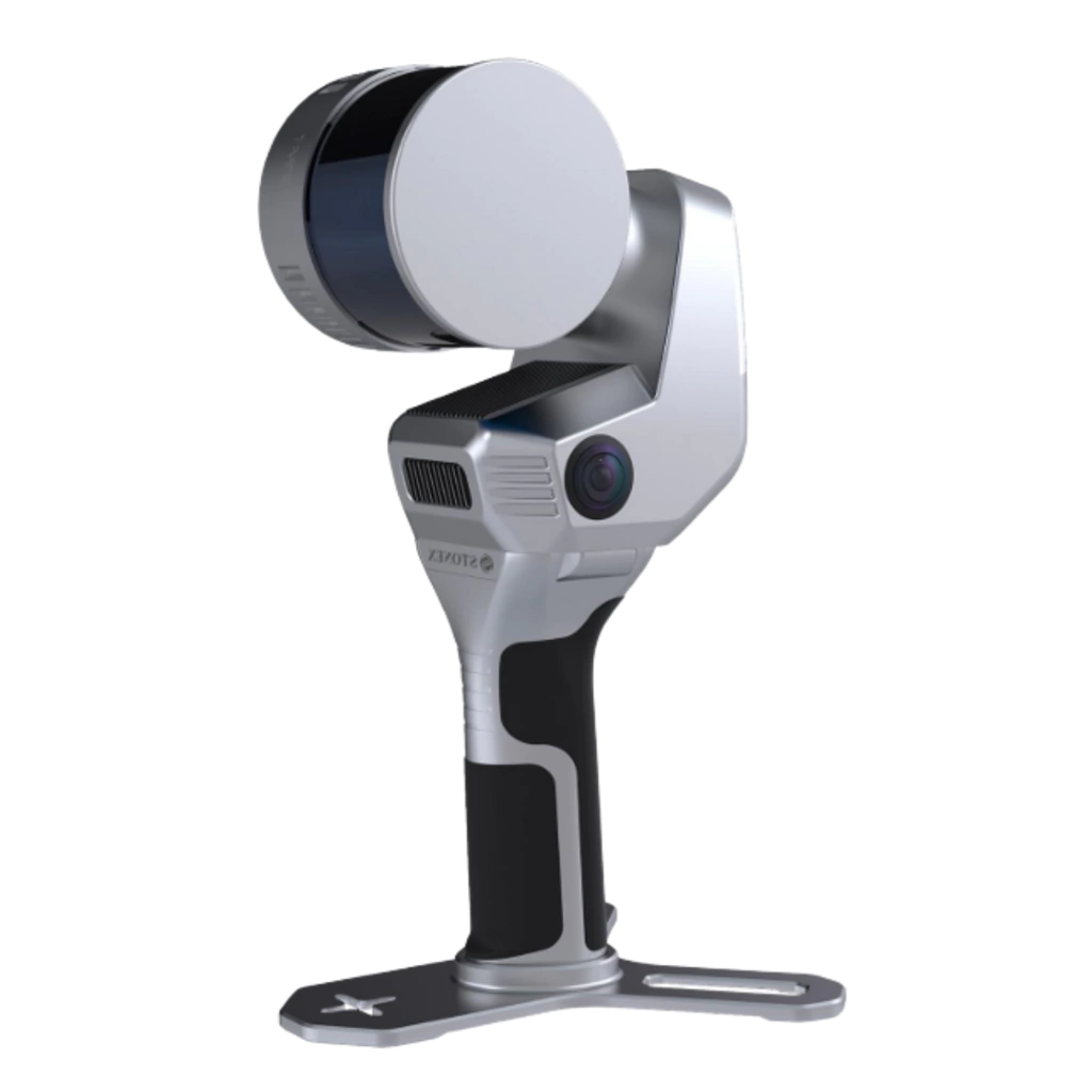
The X120GO_v2 is a compact, next‑generation handheld SLAM laser scanner designed for fast, accurate 3D data capture in both indoor and outdoor environments. With a scanning range of up to 120 metres, it is optimised for building interiors, architectural spaces, industrial facilities, and medium‑scale outdoor sites. Its rotating LiDAR head maximises beam coverage, allowing for efficient data capture even in tight or cluttered environments.
The X120GO_v2 can be used equally well indoors and outdoors oa combination of both. With the inbuit GNSS receiver and attachable antenna it can get centimetre accurate positioning using RTK via the internet or by an attachable UHF radio. There is no longer a need for GCPs making the job quicker and more efficient.
The X120GO_v2 integrates two 12‑megapixel panoramic cameras and an onboard GNSS receiver, enabling real‑time point cloud colouring and orientation. These cameras generate immersive panoramic images that overlay onto the 3D model, allowing users to visually navigate and measure within the captured environment.
A standout capability of the X120GO_v2 is its X‑Whizz hybrid scanning mode, which automatically aligns static scans with dynamic SLAM data for improved accuracy and completeness. This allows for greater resolution in important areas of the project.
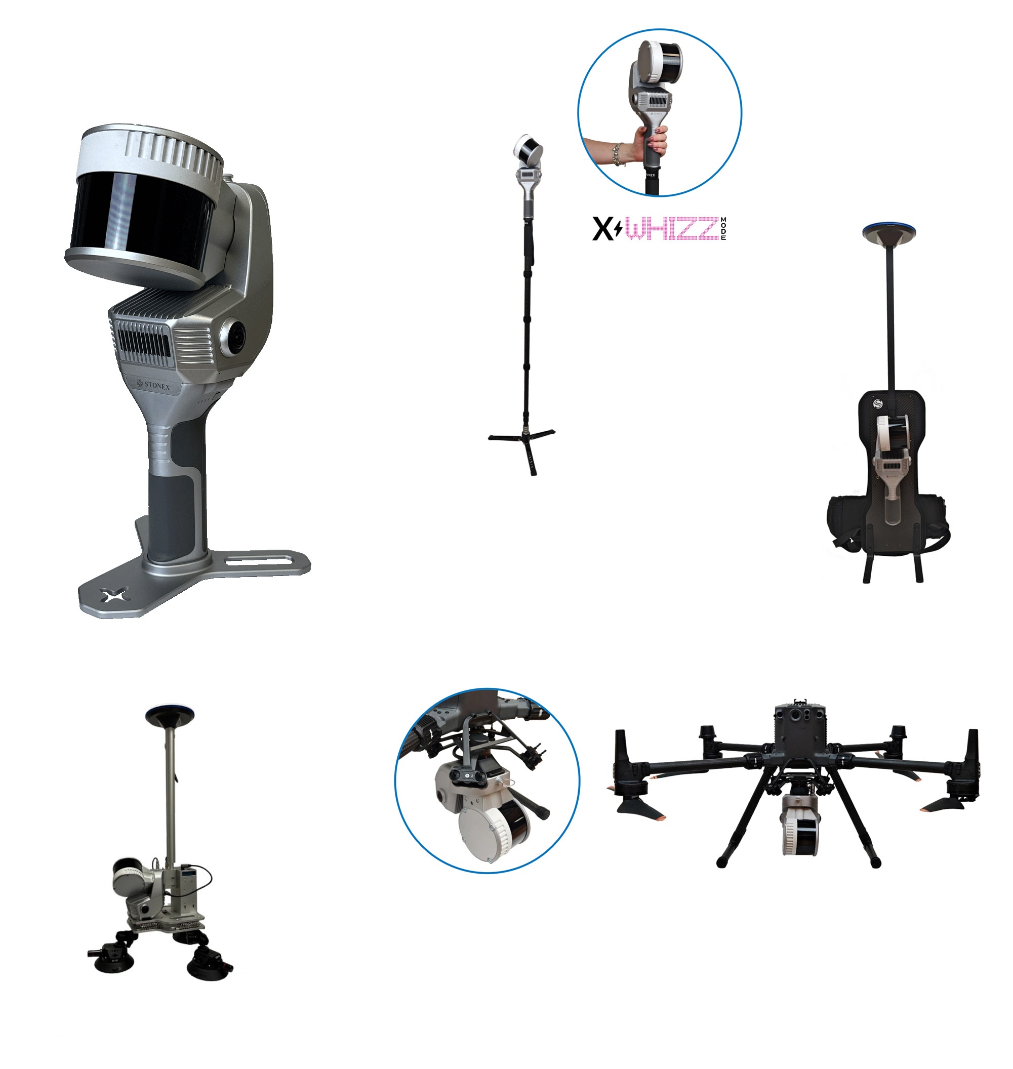
The device supports multiple mounting options—including backpack, shoulder hook, vehicle mount, and UAV integration for DJI M300/M350—offering flexibility for mobile and aerial scanning. Both the X120GO_v2 and the X200GO are suitable to be mounted to a vehicle or to a UAV. Both models support UAV workflows, and triple‑echo LiDAR make it more suitable for mapping power lines and to see through the forest canopy.
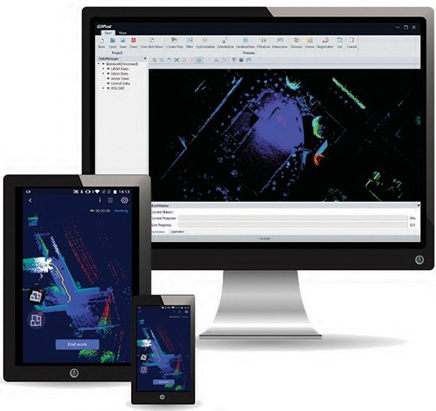
When using the the SLAM LiDAR the data capture can be viewed in realtime using Stonex’s Go App that runs on an Android tablet. It allows the user to control the device and configure for RTK positioning or to capture GCPs.
When the scan is complete the data is downloaded onto a PC and post processed into high‑resolution 3D point cloud using Stonex’s GoPost software. It can use the panoramic imagery to optimise and colour the point cloud. it can then georeference the points using either GCPs or the accurate RTK positions.
Whether creating a digital twin, stock pile measurement or creating a detailed map; the X120GO v2 delivers efficient and accurate results.
Bundled Software.
The GO App is the mobile application for X120G0_v2 to use when scanning points. It also manages projects, real time point cloud display, image preview and firmware upgrades. This App runs on the Android operating system and suited to the UniStrong / Stonex range of tablets that we sell.
GOpost is used to post-process the data collected by the X120Go_v2 to produce high-precision point clouds, local panoramas, optimize point cloud results, and the ability to browse point cloud. This software runs on Windows 10 or higher.
Stonex and 3rd party software
Stonex Cube-3d is Photogrammetric software for post processing LiDAR and photo images to create maps and volumes. It can transform image data into highly accurate digital maps and 3D models with extreme precision. It can import Stonex’s Cube-a surveys and the scanned imagery from GOpost as well as being fully compatible with any third-party 3D models.
PointCab Thanks to the collaboration between Stonex and PointCab, you can manage your point clouds with it. PointCab Origins is your Swiss army knife when it comes to the evaluation of point cloud data – working with all laser scanners and compatible with all CAD and BIM systems.
| Laser scan Performance | System Specification | ||
| Maximum range | 120 metres | Memory | 512 GB SSD) |
| Minimum range | 0.05 metres | Operating system | Controlled via GOapp (Android/iOS) |
| Relative Accuracy | Up to 6 mm (environment dependent). | Communication | Wi‑Fi, Bluetooth, USB‑C, Lemo |
| LiDAR Channels | 16 or 32 model (Hesai XT16 / XT32) | ||
| No. of points per second | XT32 model 1,280,000 (dual return) | Power Specification | |
| Field of View | 360° horizontal x 270° vertical | Power Consumption | 25 Watts |
| Laser Class | Class 1 (IEC/EN 60825‑1:2014) | Operating Time | ~1.2 hours per battery |
| Wavelength | 905 nm | Capacity | 3000 mAh |
| Camera Performance | Physical Specs. | ||
| Cameras | 2 × 12 MP (24 MP total) | Weight | 1.6 kg (without battery) / 2.1 kg (with battery) |
| Cameras FOV | 210° diagonal | Size | 404 mm × 170 mm × 188 mm |
| Image Resolution | 4000 × 3000 px | Operating Temp. | –20°C to +50°C |
| Point Cloud Colouring | Real‑time + post‑processing | Operating Humidity | < 85% Relative Humidity |
| Waterproof / Dustproof | IP54 rating |
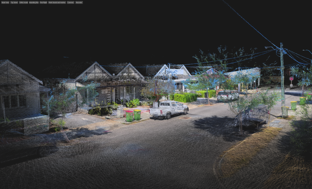
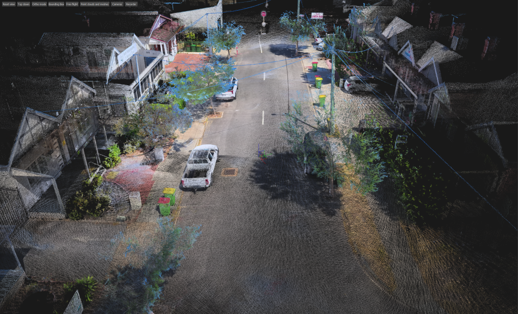
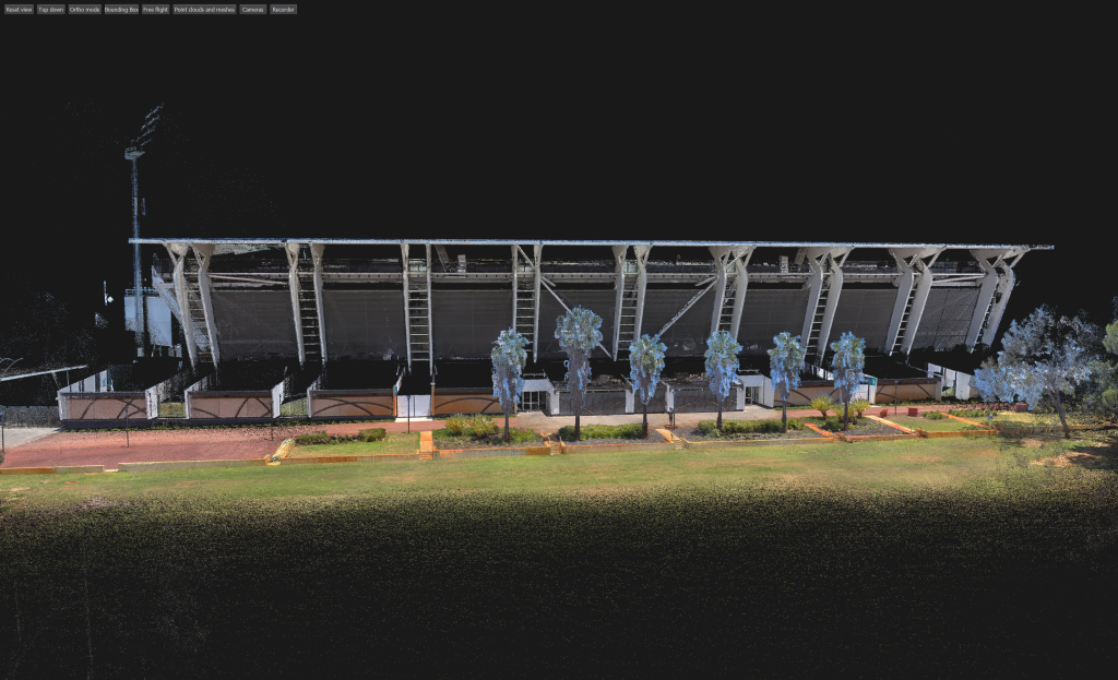
Point Clouds Captured with the Stonex X120GO_V2
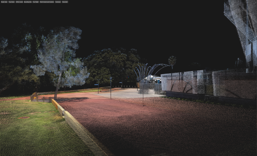
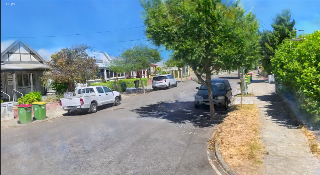
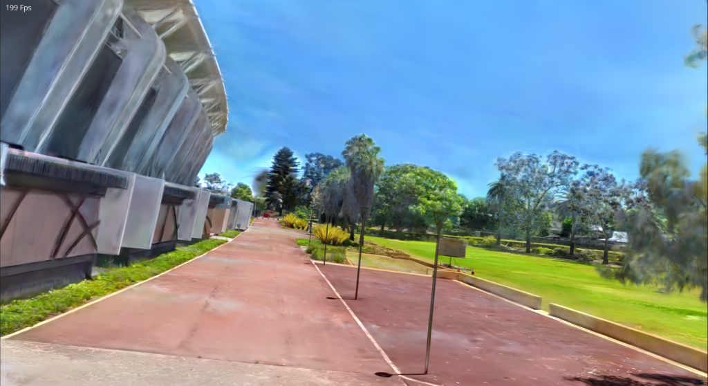
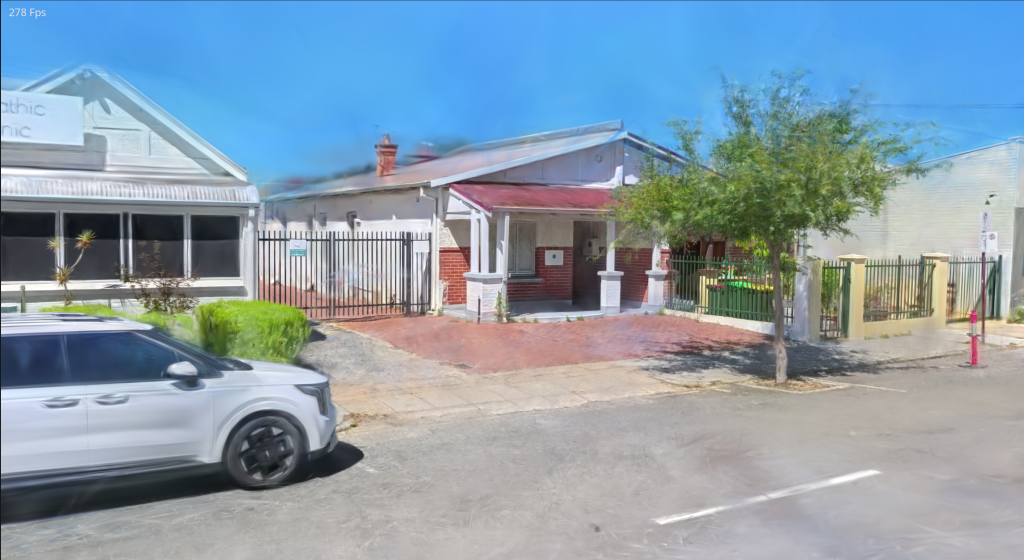
Gaussian Splat Examples from the Stonex X120GO_v2
The Stonex X120GO v2 supports advanced 3D visualisation workflows by enabling the creation of Gaussian Splat models from its SLAM‑based point‑cloud data. When paired with Insta360 panoramic Camera (purchased separately), users can generate immersive, photorealistic 3D scenes ideal for digital twins, asset documentation, and visual inspection.
This workflow is achieved using a combination of Stonex GOpost and PostShot (third‑party software):
Capture the SLAM point cloud using the X120GO v2
Add 360° imagery from an Insta360 camera
Train the Gaussian Splat model in GOpost using the captured point‑cloud dataset
Create & refine the final splat visualisation using PostShot tools
The result is a highly realistic, spatially accurate 3D representation that blends SLAM‑derived geometry with rich panoramic imagery. Below are several Gaussian Splat examples produced using this workflow, demonstrating the impressive visual quality achievable with the X120GO v2 + Insta360 combination.

X120GoV2 standard package X120GO_v2-16 16-bit version ideal for walking around Hard shell protective carry case | AUD exGST $31,000.00
|
| X120Go_v2 Accessories | |
| Battery handle – rechargeable Lithium Ion | $750.00 |
| X120Go_v2 Shoulder hook for support when walking | $1,000.00 |
| Base plate for the X120Go – replacement | $60.00 |
| Tablet holder | $270.00 |
| Telescopic pole + tripod stand | $280.00 |
| Backpack frame bundle | $2,400.00 |
| Vehicle Mount bundle for the X200Go | $4,150.00 |
| GOpost software dongle key | $450.00 |
| GOpost software office license | $400.00 |
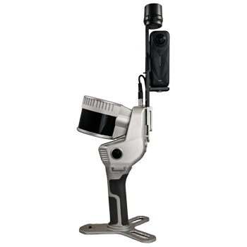
The image above shows the X120Go_v2 with the insta X5 camera and the GNSS antenna.