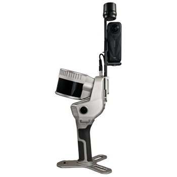
Stonex X200Go SLAM LiDAR
The Stonex X200GO is a cutting-edge handheld laser scanner powered by SLAM technology, designed to deliver fast, accurate, and georeferenced 3D data in both indoor and outdoor environments. With a scanning range of up to 300 meters and a rotating head that enhances laser coverage, it captures detailed spatial information even in complex or cluttered areas. The device integrates two high-resolution cameras and an RTK GNSS receiver, enabling real-time point cloud coloring and precise geolocation. These cameras also generate immersive panoramic images that overlay onto the 3D model, allowing users to navigate and measure directly within the visual context.
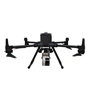
One of the standout features of the X200GO is its hybrid scanning capability through X-Whizz mode, which combines static scans with dynamic SLAM data for enhanced accuracy and completeness. This makes it ideal for documenting construction sites, architectural spaces, industrial facilities, and cultural heritage assets. The scanner supports multiple mounting options—including backpack, shoulder hook, vehicle mount, and DJI M350 drone holder—offering unmatched flexibility for mobile and aerial scanning missions.
Data captured by the X200GO can be processed into high-resolution point clouds and textured meshes, suitable for BIM workflows, inspection, and digital twin creation. Its intuitive software ecosystem streamlines data management, visualization, and export, making it a powerful tool for professionals in surveying, engineering, and geospatial analysis. Whether navigating tight corridors or scanning expansive outdoor areas, the X200GO delivers reliable, high-speed 3D mapping with minimal setup and maximum mobility.
The X200GO Standard package is $45,000 exGST and includes:
• Hard shell protective case
• Handle with internal lithium-ion battery
• Mounting base compatible with multiple configurations
(backpack, shoulder hook, vehicle, and drone)
• AC wall charger and power cable
• GO App for Android tablet
• GOpost software and USB dongle for data processing
• Calibration test report
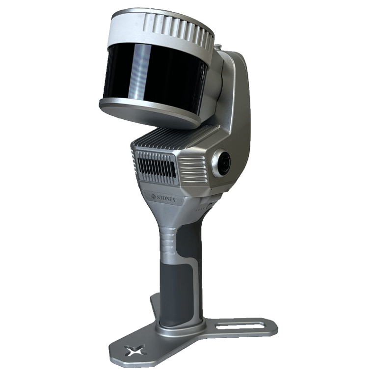
The X200GO features two integrated high-resolution cameras that work in tandem with its rotating laser head to capture colored point cloud imagery and immersive panoramic images. These visuals are superimposed onto the 3D model, enabling intuitive navigation and precise measurements within the real-world context.
This versatile SLAM-based scanner is ideal for dynamic 3D mapping across indoor and outdoor environments, offering hybrid scanning via X-Whizz mode and real-time georeferencing with its integrated RTK GNSS receiver.
Accessories if required
Battery handle is $750 exGST
Tablet holder is $270 exGST
Shoulder hook to support the X200Go when walking is $1,000 exGST
Backpack frame bundle is $2,400 exGST
Vehicle mount bundle is $4,150 exGST
UAV platform to suit DJI M350 is $1,200 exGST


Bundled Software Ecosystem
• GOapp (Android & iOS):
A mobile application for managing projects, previewing images, displaying real-time point clouds, and performing firmware upgrades. It ensures seamless field operations and immediate feedback during data capture.
• GOpost (Windows):
A powerful post-processing tool that refines scan data, applies color to point clouds, and generates panoramic visuals. It also allows the import of control points for precise georeferencing.
• X200GO-Web:
A web-based platform for data sharing, visualization, and remote collaboration, streamlining project workflows across teams.
Key Advantages
• Hybrid Scanning with X-Whizz Mode:
Combines mobile SLAM scanning with stationary high-resolution capture by pausing briefly in key areas, achieving both speed and detail.
• Rapid Data Collection:
Eliminates the need for multiple scan stations—simply walk through the environment to capture a complete 3D point cloud.
• Real-Time Results:
The visual camera and robust SLAM algorithm ensure stable performance even in low-texture environments, with data ready immediately after the survey.
• Automatic Control Point Measurement:
Detects and records reference points during capture, which can be matched with known control points for accurate georeferencing.
• Flexible Mounting Options:
Compatible with poles, backpacks, vehicles, and drones, the X200GO adapts to diverse surveying scenarios.
Whether you’re scanning architectural interiors, construction sites, or outdoor landscapes, the X200GO offers a powerful, efficient, and user-friendly solution for creating high-quality 3D models.
| Stonex X200GO | Specifications |
|---|---|
| LIDAR | |
| Sensor Model | Hesai XT32M2X |
| Max Range | 300 m |
| Min Range | 0.5 m |
| Return Number | 3 |
| Single Return Rate | 640,000 pts/s |
| Scanning Frequency | Not specified |
| Field of View | 360° x 290° |
| Laser Class | 1 |
| Channels | 32 |
| Wavelength | 905 nm |
| Color Camera | |
| Number of Pixels | 24 MPx (2 cameras, 12 MPx each) |
| Diagonal FOV | 210° |
| Focal Length | 1.26 mm |
| Resolution | 4000 x 3000 px |
| Sensor Size | 1/2.3 inch |
| Pixel Size | 1.55 µm |
| GNSS Receiver | |
| Satellite Signals | GPS L1 C/A/L2P(Y)/L2C/L5, GLONASS G1/G2, Galileo E1/E5A/E5B, BDS B1I/B2I/B3I, QZSS L1/L2/L5 |
| DGPS Accuracy (RMS) | Horizon: 0.4 m + 1 ppm; Vertical: 0.8 m + 1 ppm |
| RTK Accuracy (RMS) | Horizon: 0.8 cm + 1 ppm; Vertical: 1.5 cm + 1 ppm |
| Speed Accuracy (RMS) | 0.03 m/s |
| System | |
| Relative Accuracy | Up to 6 mm |
| Global Accuracy | Up to 2 cm; 5 cm on UAV platform |
| Control Point Support | Ground & wall |
| Data Storage | 512 GB SSD |
| Communication | Wi-Fi, Bluetooth, USB Type-C, Lemo connector |
| Operating Modes | SLAM & X-Whizz modes |
| Processing Modes | GoPost Post-processing of data for visualization, coloring, and orientation |
| Electrical Specs | |
| Power Consumption | 26 W |
| System Supply Voltage | 20 V |
| Operating Time | 3.2 h (single battery) |
| External Power | USB Type-C |
| Battery Input Voltage | 5–20 V |
| Battery Output Voltage | 10.8 V |
| Battery Capacity | 3000 mAh |
| Physical Specs | |
| Weight | 1.4 kg (without battery); 1.9 kg (with battery) |
| Dimensions | 403.6 mm x 173.8 mm x 170 mm |
| Operating Temperature | -20°C to +50°C (-4°F to 122°F) |
| Operating Humidity | <95% |
| Waterproof/Dustproof | IP54 |
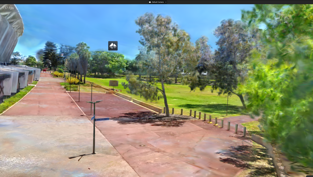
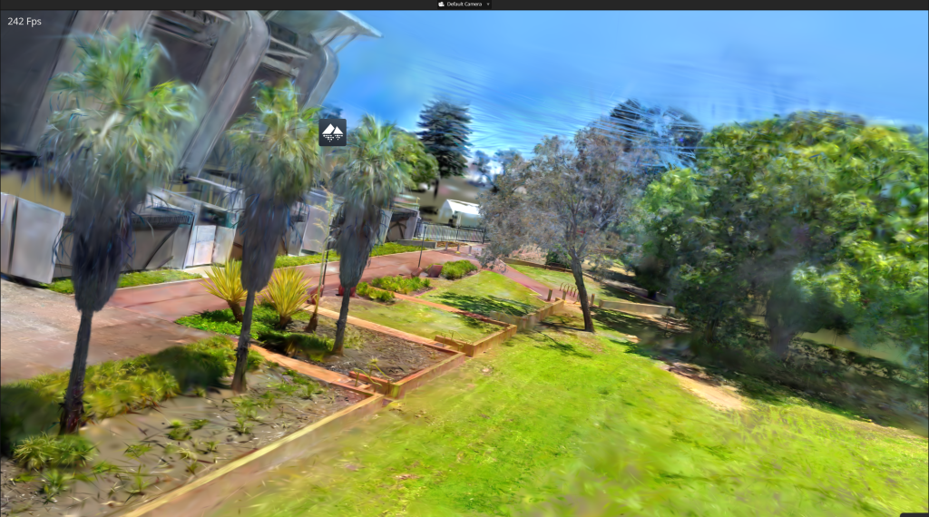
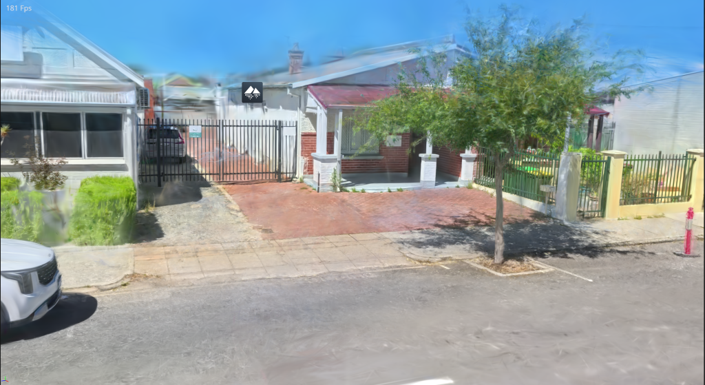
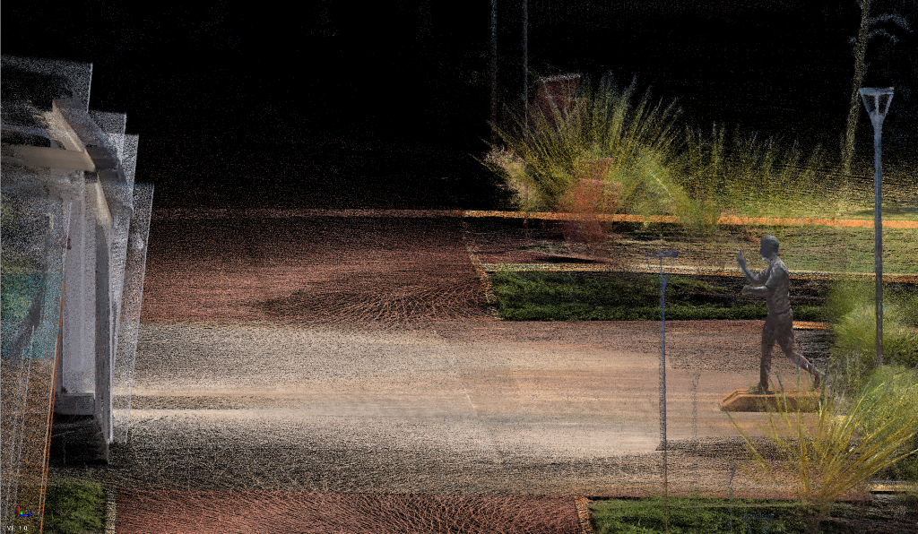
Examples of Point Clouds Captured with the Stonex X200Go
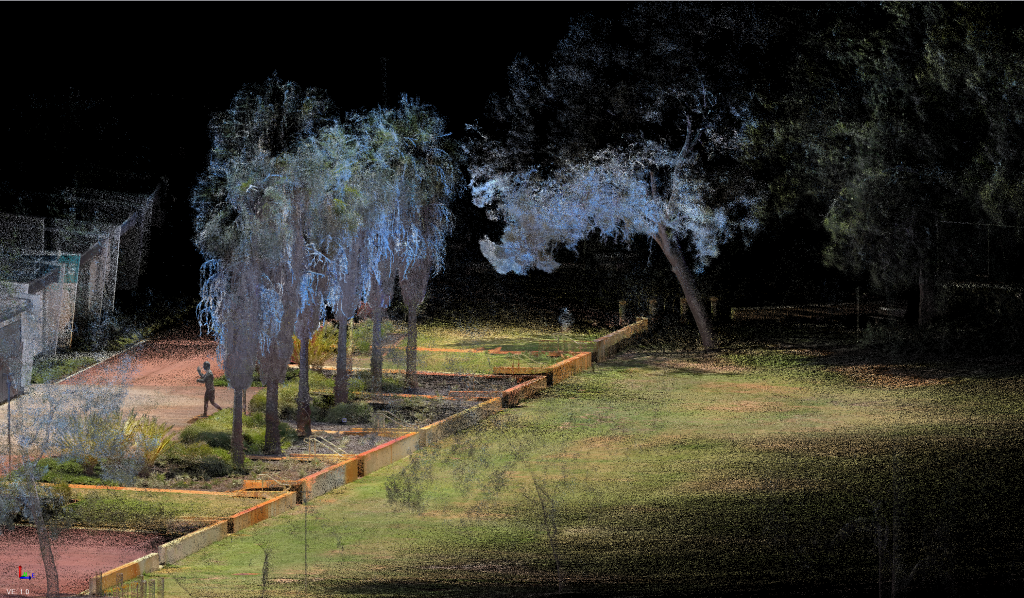
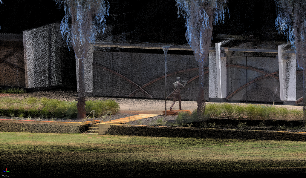
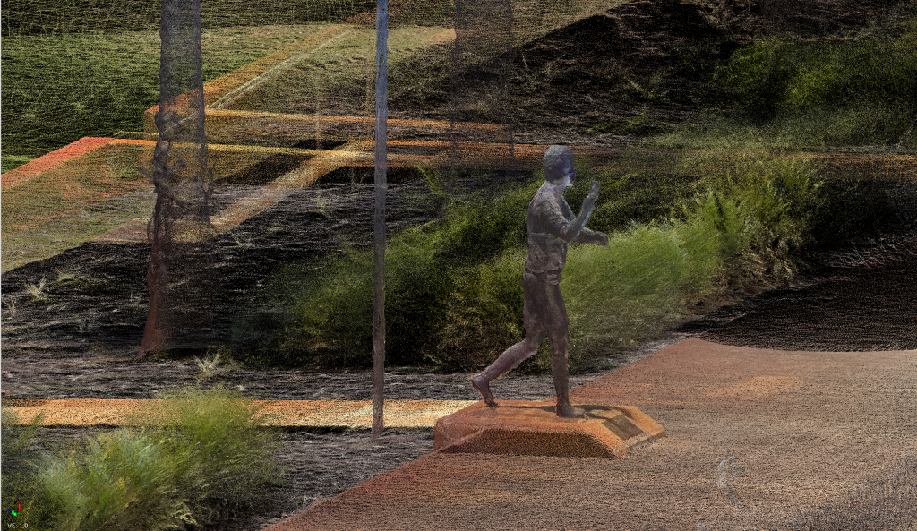
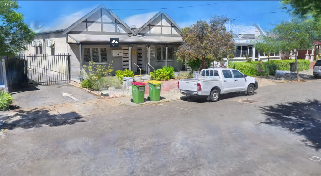
The Stonex X200GO opens the door to advanced 3D visualisation workflows by enabling the creation of Gaussian Splat models directly from its high‑density, long‑range point‑cloud data. When combined with imagery captured using an Insta360 camera (purchased separately), users can generate immersive, photorealistic 3D scenes ideal for digital twins, asset documentation, and visual inspection.
This enhanced workflow is supported through a combination of Stonex GOpost and PostShot (third‑party software):
Capture the point cloud using the X200GO
Add 360° imagery from an Insta360 camera
Train the Gaussian Splat model in GOpost using the captured point‑cloud dataset
Create & refine the final splat visualisation using PostShot tools
The result is a highly realistic, spatially accurate 3D representation that blends geometric precision with rich visual detail. Below are several Gaussian Splat examples produced using this workflow, demonstrating the impressive quality achievable with the X200GO + Insta360 combination.